02 — Getting Around
Forget Google Maps pin drops. Learn the bones of the neighborhood first.
Time to learn: 25 minutes
When you'll use it: Every time you give or receive directions
How Locals Give Directions
In Indiranagar, you navigate by landmarks and cardinal zones, not street addresses. Nobody says "4th Cross, HAL 2nd Stage" — they say "behind 12th Main" or "BDA Complex side."
The delivery guy knows "near the Water Tank." Your auto driver knows "KFC Signal hatra." Your building guard knows "Defence Colony, Indiranagar side." Street names are decorative.
The Cardinal Landmarks
Memorize these six. They're your navigation anchors.
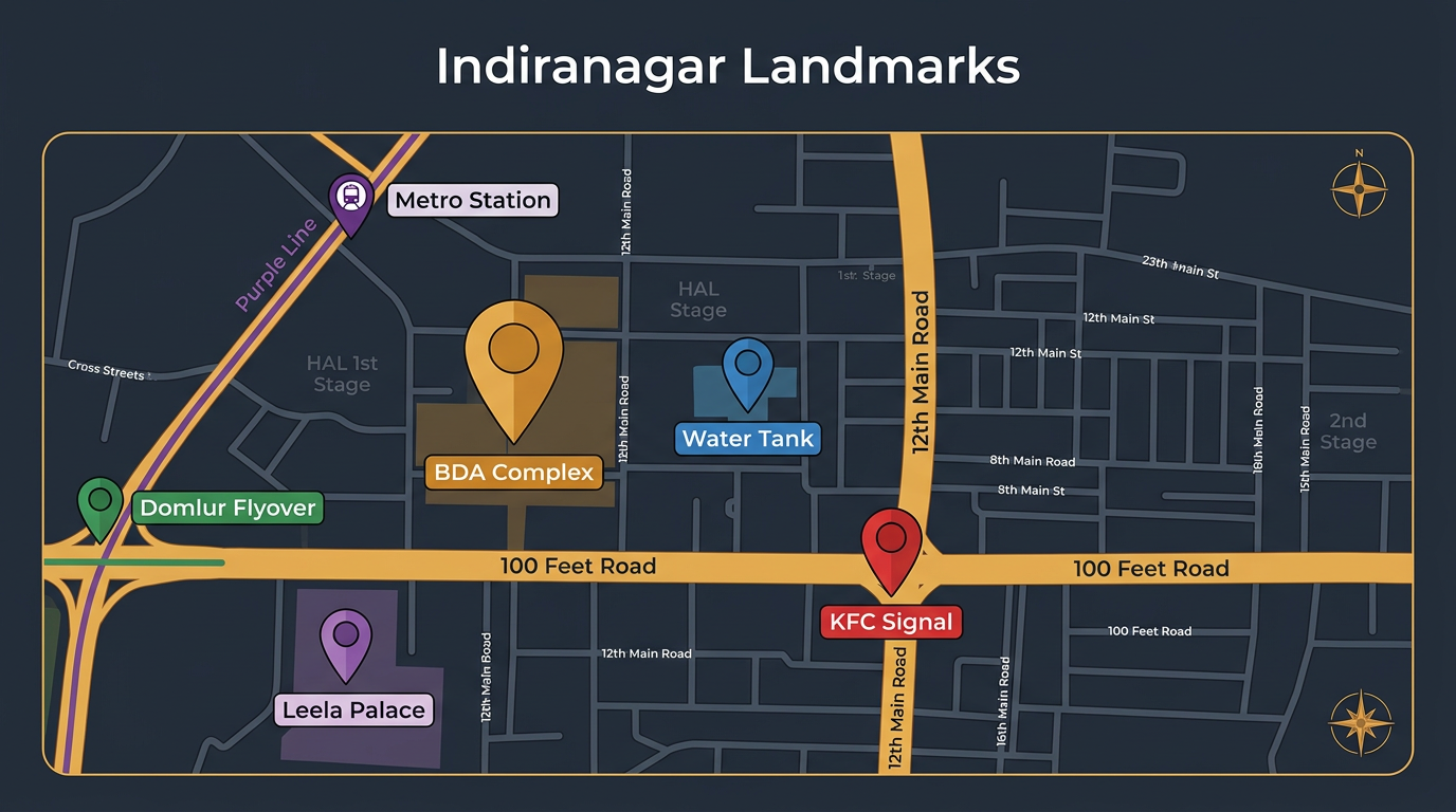
| Landmark | What It Is | Why It Matters |
|---|---|---|
| BDA Complex | Municipal commercial hub near 100 Feet Road | Auto stand, shops, central reference point |
| The Water Tank | Large overhead water tank in HAL 2nd Stage | Ancient navigation anchor. "Past the Water Tank" = standard direction |
| KFC Signal | Junction at CMH Road + 100 Feet Road | KFC is gone (now a Snitch store), but "KFC Signal" lives forever in auto driver memory |
| Domlur Flyover | The flyover connecting Indiranagar to Domlur | Eastern boundary marker. "Domlur side" = east of the neighborhood |
| Leela Palace side | The Leela Palace hotel area | Southwestern corner. Marks where Indiranagar meets the Air Force boundary |
| Indiranagar Metro | Purple Line metro station on 100 Feet Road | Eastern anchor on the main road |
The Zone Language
These micro-zone descriptions will make more sense than any address:
| Locals Say | What It Means |
|---|---|
| "Behind 12th Main" | Residential lanes north of the pub strip. Quieter PGs, tree-lined streets. |
| "100 Feet Road pub side" | The 12th Main intersection zone. Toit, cafés, the chaos. |
| "100 Feet Road Domlur side" | Eastern stretch, calmer, more residential. |
| "Defence Colony, Indiranagar side" | Specify "Indiranagar side" or delivery goes wrong part of city. |
| "Near Double Road" | Old Airport Road, the divided arterial running south. |
| "HAL 2nd Stage interior" | Deep residential grid, well inside, away from main roads. |
| "BDA Complex side" | Commercial area near the complex — tailors, shops, hardware. |
The Direction Phrases
| Kannada/Kanglish | Phonetic | English |
|---|---|---|
| [Place] elli ide? | ⟨el-li i-de⟩ | Where is [place]? |
| Edakke tirgi | ⟨e-duk-ke tir-gi⟩ | Turn left |
| Balakke tirgi | ⟨bul-uk-ke tir-gi⟩ | Turn right |
| Nera hogi | ⟨nay-ruh hoh-gi⟩ | Go straight |
| [Place] hatra | ⟨hut-ruh⟩ | Near [place] / Close to [place] |
| Doora ide | ⟨doo-ruh i-de⟩ | It's far |
| Hathra ide | ⟨hut-ruh i-de⟩ | It's nearby |
| Walk maadbauda? | ⟨walk maad-buh-daa⟩ | Can I walk? (Kanglish — perfectly understood) |
| Meter eshtu? | ⟨mee-tur esh-tu⟩ | How far on the meter? |
Giving Directions to Someone Else
When someone asks you for directions, use landmarks:
"BDA Complex hathra hogi, Water Tank past maadi, eradu cross bitta left tirgi." (Go near BDA Complex, pass the Water Tank, turn left after two crosses.)
Pure Kanglish, perfectly clear to anyone who lives here.
The Arterial Roads
100 Feet Road (spine): The main artery. Pub strip, cafés, boutiques. The stretch between Domlur flyover and Defence Colony junction — about 1.5 km. Now genuinely walkable with good footpaths after the 2023–24 road widening.
12th Main (soul): Runs perpendicular from 100 Feet Road into the residential interior. Lower stretch = pubs, cafés (Toit). Walk 5 mins north = tree-lined, residential, quiet.
CMH Road (western edge): More commercial. Banks, supermarkets, Nilgiris. Useful for errands.
Old Airport Road (southern edge): Fast, wide, arterial. Avoid 8:30–10 AM and 5:30–8 PM.
Metro: When It's Worth It
Indiranagar Metro Station (Purple Line) is a 10–15 min walk from 12th Main. If you're in HAL 2nd Stage, 15–20 mins on foot or a quick auto hop.
It's second-highest footfall in the city. Reliable, air-conditioned, ₹15–45 depending on distance.
Useful metro routes from Indiranagar: - → MG Road: 3 stops (~8 mins) - → Majestic/Kempegowda (interchange to Green Line): ~25 mins - → Baiyappanahalli: 2 stops east
Metro timing: First train ~5 AM, last ~11 PM. Least crowded: before 8 AM and between 2–4 PM.
Token machines take cash. Get a stored-value Namma Metro card if you commute daily — saves time at entry gates.
Cab Surge Patterns
Ola and Uber surge in Indiranagar follows a predictable cycle:
| Time | Surge Level | What To Do |
|---|---|---|
| Morning rush 8:30–10 AM | 1.2x–1.8x | Book from a side lane, not main road |
| Afternoon lull 1–4 PM | Base or minimal | Best time for longer trips |
| Evening rush 5:30–8:30 PM | 1.5x–2.5x | Walk 2 blocks into residential, then book |
| Fri/Sat night 9 PM–1 AM | 2x–3x near 100 Feet Road | Walk away from the main road before booking |
| Rain | Nuclear | Wait 30–40 mins or take metro |
Walkability: Indiranagar Is Now Actually Walkable
After years of construction, dust, and craters, Indiranagar emerged with: - Wide, even footpaths on 100 Feet Road - 12th Main is a comfortable stroll - Defence Colony tree-lined lanes — the best evening walk in the neighborhood - HAL 2nd Stage residential lanes — low traffic, shaded
Realistic walks: - Metro station → 12th Main pubs: 12 mins - BDA Complex → Defence Colony: 15 mins - Your darshini → your flat: probably 8 mins
The 1.5 km rule: If it's under 1.5 km and not raining, walk it. You'll beat the auto negotiation time anyway.
Parking (For Two-Wheeler Riders)
- On 100 Feet Road: Park in side lanes one block away. Main road parking gets challaned after 6 PM.
- Near BDA Complex: Commercial lot usually has space.
- Near 12th Main pubs: Most have valet or designated spots. Don't block residential gates — the residents will call traffic police, and they respond.